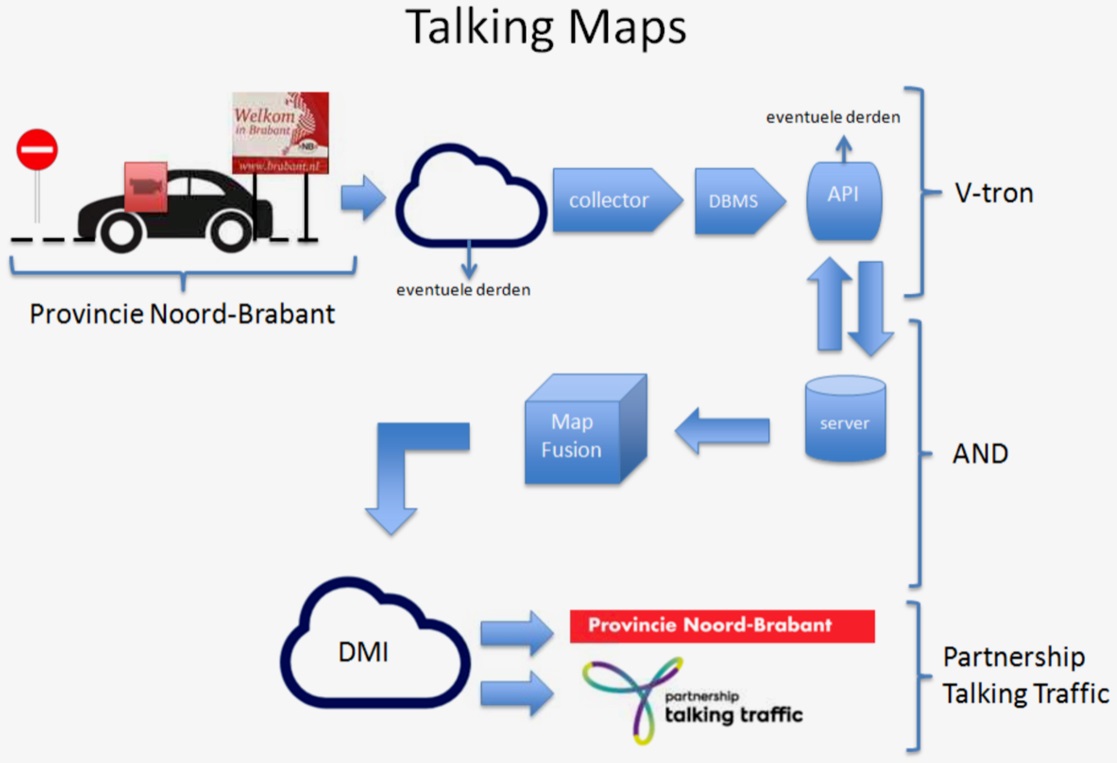
Goal of Talking Maps
The development of detailed maps is in full swing, requiring large amounts of sensor data. There is no industry standard for high-definition maps yet.
The goal of the Talking Maps trial is to:
- To explore which data elements can be added to a map, using standard sensor data from road maintenance vehicles, and with what reliability, usability and frequency these data elements can be made available for use by public authorities (asset management, possible applications in the field of traffic management);
- The standard sensor referred to here is an intelligent vision sensor, which in normal use is characterised as ADAS. This sensor also checks which data elements are missing that are essential for the final process. It is beyond the scope of this project to be able to obtain these missing elements using alternative sensors.
- Exploring the value of this data and maps or other datasets, given developments in CAD (level 4.5), both nationally and internationally;
- Actively involve road authorities in developments in the field of smart mobility and generate enthusiasm for these developments.
Project approach
The development of sensors and connectivity, which can assist in the development of HD Maps, is advancing rapidly. One of the objectives is to obtain the most complete digitalised image of the road possible for automated transport. Generating additional data through the use of road maintenance vehicles can contribute to the development of detailed maps. Road maintenance vehicles were deliberately chosen because they are always active in a limited area and drive the same route more frequently. This makes it easier to compare the data collected.
Research questions include:
- How quickly can extra data from road authority vehicles be turned into a usable map?
- How useful and complete is that material in relation to the desired purpose (both CAD and smart asset management)?
- To what extent does the map that is created contribute to or deviate from international map standards?
- To what extent can this data contribute to the validation of data from other sources for the purpose of HD maps?
Contact V-tron:
Results achieved
This is a proof-of-concept lasting a maximum of two years. The aim is to find the right balance between collection efforts, standardisation (quality and usability of map material) and contribution to the ambitions and operations of businesses and public authorities.
The following added value is seen for asset management:
- Efficiency through targeted functional inspection. Visual inspection of the entire area can potentially be reduced from twice a week to once a week.
- By making the data available to the contract partners, fewer kilometres need to be driven and signs are replaced more quickly.
- Better service for road users and shorter response times. Signs and changes to the digital visibility of signs are clearly visible.
- This can lead to cost savings (materials, equipment, man-hours). When using contract partners, these cost savings can lead to lower prices. More efficient use of own vehicles can also lead to cost savings. Or other use of vehicles, enabling a faster response to IM reports. WIS vehicles that are on the road for inspection stop inspecting as soon as an IM report comes in, if the road inspector is nearby.
- For the time being, digital signs cannot partially or completely replace physical signs.
Challenges
Privacy
The vision sensor is not a traditional camera and does not in any way “record video or photos” of the situation outside the vehicle. Objects on and next to the road are “recognised”, and in the event of such detection, data is sent. This is event-driven communication, whereby the event is detected and characterised in the sensor. Only this characterisation data is communicated. These events are not timestamped and are therefore not traceable or trackable. Potentially privacy-sensitive elements such as number plates and characteristics of other road users are not recorded or shared.
Data quality
- Depth measurements: distances to objects and thus the location of objects. Location is determined using GPS in the on-board unit (CAN bus) and is subject to the known limitations of GPS in this area.
- Confidence levels: the more frequently an object is observed, the higher the confidence levels with which the object is presented in the data.


